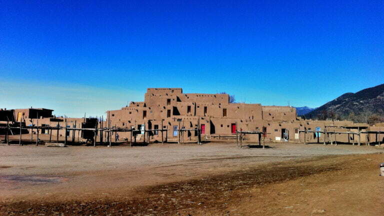
Chaco Culture, also known as Chaco Canyon, is an ancient archaeological site in the southwestern United States that holds great historical and cultural significance. Here’s an overview of Chaco culture:
Chaco Culture National Historical Park
1. Chaco Culture: Chaco Culture National Historical Park, situated in the American Southwest, is a remarkable United States National Historical Park that features a concentration of ancient pueblos. Located in northwestern New Mexico, nestled between Albuquerque and Farmington, this park is set within a remote canyon carved by the Chaco Wash. It is renowned for preserving one of the most significant pre-Columbian cultural and historical regions in the United States.
2. Chaco Canyon, New Mexico: Between the years AD 900 and 1150, Chaco Canyon stood as a thriving cultural center for the Ancestral Puebloans. The Chacoans demonstrated their remarkable architectural skills by quarrying sandstone blocks and transporting timber from distant locations. They erected fifteen major complexes, which remained the largest buildings ever constructed in North America until the 19th century.
Their architectural achievements are often associated with precise astronomical observations, as exemplified by the famous “Sun Dagger” petroglyph on Fajada Butte. Many Chacoan structures are believed to have been aligned to track the solar and lunar cycles, a feat that required generations of astronomical expertise and centuries of meticulously coordinated construction.
However, a changing climate, including a prolonged fifty-year drought that commenced in 1130, is thought to have triggered the emigration of the Chacoans and the eventual abandonment of the canyon.
3. Pueblo peoples: For over two millennia, Pueblo peoples inhabited an expansive region in the southwestern United States. Chaco Canyon, a prominent hub of ancestral Pueblo culture between 850 and 1250, held significance for ceremonies, trade, and political activities in the prehistoric Four Corners area. What sets Chaco apart is its monumental public and ceremonial buildings, as well as its unique architectural style. It boasts an ancient urban ceremonial center that remains unmatched by any construction before or since.
4. Aztec Ruins National Monument: In addition to Chaco Culture National Historical Park, the World Heritage property includes the Aztec Ruins National Monument and several smaller Chaco sites managed by the Bureau of Land Management. Together, these sites offer a comprehensive view of the remarkable cultural, architectural, and historical achievements of the ancient inhabitants of the American Southwest.
Chaco Culture is a testament to the advanced architectural and cultural achievements of the Ancestral Puebloans and continues to be a site of historical and archaeological interest. Here are some interesting facts about Chaco culture:
Facts about Chaco Canyon
5. Location: Chaco Culture is located in northwestern New Mexico, in the Four Corners region of the United States. It lies within Chaco Culture National Historical Park.
6. Ancient Civilization: The site was once the center of an ancient Native American civilization known as the Ancestral Puebloans or Anasazi, who inhabited the area from around the 9th to the 13th century.
7. Architecture: Chaco Culture is renowned for its remarkable architecture, featuring multi-story stone structures, including kivas (ceremonial underground rooms) and great houses.
8. Great Houses: The great houses, such as Pueblo Bonito and Chetro Ketl, are massive, well-planned structures that served as centers for community and ceremonial activities.
9. Solar and Lunar Alignments: Chaco’s architecture displays a sophisticated understanding of celestial alignments. Many structures are thought to have been built with specific alignments to solstices and lunar events.
10. Trade and Cultural Exchange: Chaco Canyon served as a hub for trade and cultural exchange, with evidence of goods like turquoise, shells, and macaw feathers coming from distant regions. It was connected to distant regions, indicating a complex network of interactions with other Native American communities.
11. Great Houses: Chaco Canyon is known for its massive stone structures, called “great houses.” The most famous among them is Pueblo Bonito, a complex of over 600 rooms.
12. Sophisticated Roads: The Chacoans constructed an extensive network of roads, some of which stretch for miles, connecting the great houses and outlier communities.
13. Outlier Communities: Chaco Culture included outlier communities located beyond Chaco Canyon, connected through road networks. These communities played a significant role in the Chacoan civilization.
14. Ancestral Puebloan Culture: The Ancestral Puebloans, also known as Anasazi, left behind a rich legacy of pottery, petroglyphs, and architectural wonders, all of which can be explored at the site.
15. Mysterious Decline: The civilization at Chaco Culture experienced a sudden and unexplained decline in the late 13th century, leading to the abandonment of the site. The reasons for this decline remain a subject of archaeological debate.
16. Preservation and Study: Today, Chaco Culture is a protected area, and ongoing research and preservation efforts provide valuable insights into the daily lives, practices, and architecture of the ancient inhabitants.
17. UNESCO World Heritage Site: Chaco Culture was designated as a UNESCO World Heritage Site in 1987 for its cultural and historical significance. Chaco Culture continues to be a site of fascination and study, offering valuable insights into the achievements and mysteries of an ancient Native American civilization.
