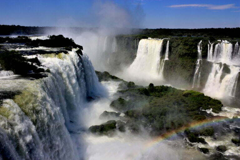
Iguazu National Park, or Iguazu Falls, is located in Misiones Province in the northeastern tip of Argentina and was a UNESCO World Heritage Site from 1984 onwards. It also shares a northern border with the Brazilian state of Parana. Iguazu National Park, together with its Brazilian sister park Iguaçu, is one of the world’s most physically and sonically impressive natural places, thanks to its tremendous waterfalls.
Iguazu Falls Argentina
Alvar Nunez Cabeza de Vaca was the first Spanish traveler to reach the falls in 1541. Edmundo de Barros, a Brazilian army colonel, proposed creating a national park near Iguaçu Falls in 1897. Following border rectifications between Brazil and Argentina, each country established its own national park: Iguacu National Park in Brazil (1939) and Iguazu National Park in Argentina (1934).
Both parks were established to conserve the falls’ flora, wildlife, and visual splendor. The Argentine park was named a UNESCO World Heritage site in 1984, while the Brazilian park was accorded World Heritage status two years later. Three airports in Argentina, Brazil, and Paraguay service the Iguazu region.
The region’s flora is diverse and abundant, ranging from semi-deciduous to tropical, and has long attracted botanists. A family of water plants called Podostemaceae thrives solely in flowing water and may be found on the ledges of the falls. Orchids grow next to pines, bamboo next to palm trees, and mosses grow next to lianas and colorful begonias, providing plenty of contrast.
Animal life is as diverse and plentiful, but it has received far less attention. Iguanas are frequently seen. Several members of the cat family (ocelots and jaguars) are among the mammals, as are deer, tapirs, and a plethora of smaller creatures. There are also toucans and a variety of other species to be found. Dorado (golden salmon), mandi, and cascudo are some of the fish found in the area.
Iguazu National Park Facts
Iguazu Falls is one of the most beautiful waterfalls in the world. It is one of Argentina’s most well-known monuments and one of Brazil’s most spectacular natural marvels. This UNESCO World Heritage Site attracts around 1.5 million tourists each year. So, whether you’re planning a trip or just want to learn more about Iguazu Falls, here are some intriguing facts.
Iguazu National Park is a subtropical rain forest located in Argentina’s Misiones region, near the Brazilian border. The Iguazu Falls, which are located on the Iguazu River, are one of the park’s most well-known attractions. The Devil’s Throat is a section of the waterfalls.
The rest of the park is home to coatis, jaguars, and toucans, among other animals. A number of walking routes and viewing platforms are also available. This park is one of Brazil’s most popular, and it sits on the border of two neighboring countries: Argentina and Paraguay. In Argentina, it is known as Puerto Iguazu.
The waterfalls may be explored on foot or by boat, which takes you close to the falls. A bird park, which is home to numerous local species as well as a conservation project, is also located within the park. Let’s look at some Iguazu National Area facts now that we’ve covered the basics of the park.
The Iguazu Falls are found in both Argentina and Brazil
The Iguazu Falls are located on the border between Argentina and Brazil. The Falls are located in the Brazilian state of Paraná. Cataratas do Iguaçu is the Portuguese name for the falls. The falls are located in the region of Misiones in Argentina. The falls are known as Cataratas del Iguazu in Spanish.
Iguazu Falls consists of 275 separate waterfalls
On the Iguazu River, the Iguazu Falls, sometimes known as Iguaçu Falls, are located. The higher and lower Iguazu rivers are separated by the waterfalls. Iguazu Falls is the world’s biggest waterfall system, with around 275 different falls in the form of a horseshoe. The majority of the falls (about 80%) occur on the Argentine side.
Iguazu Falls are larger and more powerful than Niagara Falls
Eleanor Roosevelt, the First Lady of the United States, is said to have visited Iguazu Falls in 1944. “Poor Niagara,” she cried. Iguazu Falls are higher and wider than Niagara Falls, measuring 269 feet (82 meters) high and 8,858 feet (2,700 meters) wide. Niagara Falls, on the other hand, has a higher flow rate than Iguazu Falls.
Iguazu Falls generates electricity for both Argentina and Brazil
Iguazu Falls, like Niagara Falls, supply power for the two nations they separate. The two governments, Brazil and Argentina, have taken full advantage of the spectacular losses. It produces at least 40% of the power needed in both nations.
There are more than 14 drips in the Devil’s Throat
The “Garganta del Diablo” (Devil’s Throat), a U-shaped rock with 14 falls plummeting more than 260 feet, is the most magnificent of all the falls (80 metres). The Devil’s Throat receives around half of the water flow from the Iguazu River. Garganta del Diablo is a 260-degree waterfall with water coming from three sides that generates a tremendous sound. The Devil’s Throat’s deafening roar may be heard from kilometers away.
Iguazu means “huge water” in Spanish
The Guarani word Yguasu was used to name the Iguazu Falls. The Guarani language is one of Paraguay’s official languages. The falls are known as Chororo Yguasu in the native tongue. “Y” stands for water, while “ûasu” stands for large. As a result, Iguazu translates as “huge water.”
Iguazu National Park is a World Heritage Site
Iguazu National Park consists of two separate national parks. Puerto Iguazu is a national park in Argentina that was established in 1934. In 1939, the Brazilian National Park of Foz de Iguazu was established. The Iguazu Falls were designated as a World Heritage Site as an area of outstanding universal importance by UNESCO in 1984.
Around 2000 plant species, 80 tree species, 400 bird species, including the elusive Harpy Eagle, and various wild cat species, including ocelots and jaguars, may be found in the national parks. Rare species such as the broad-snouted caiman, a crocodilian reptile, call it home. The national park is also home to tapirs, gigantic anteaters, and howler monkeys.
Share to stand out from the crowd with this Blog.


